
Hurricane downgraded to Category 2
Hurricane Laura was downgraded to a Category 2 hurricane as it moved inland Thursday morning with maximum sustained winds of 110 mph, according to the National Hurricane Center.
According to the Saffir-Simpson Hurricane scale provided by the center, a Category 2 storm is defined by “extremely dangerous winds” that will cause extensive damage while a Category 3 hurricane’s winds may cause “devastating damage.”
Laura made a landfall as a Category 4 storm on the southwestern Louisiana coast early Thursday.
Laura strongest hurricane to make landfall in Louisiana in 164 years
When Laura made landfall with 150 mph winds early Thurday, it became the strongest hurricane to hit Louisiana in 164 years, NBC meteorologist Bill Karins said.
Its winds were the strongest of any hurricane making landfall in the state since the Last Island Storm in 1856, according to Karins.
“Laura is also now tied for the most intense hurricane landfall on record in the state of Louisiana and ranks as one of the most powerful hurricane landfalls in U.S. history,” he added.
Threat of tornadoes in parts of Louisiana, Arkansas and Mississippi
There is a threat of possible tornadoes on Thursday over parts of Louisiana, Arkansas, and western Mississippi as Hurricane Laura moves inland, according to the National Hurricane Center.
The National Weather Service Storm Prediction Center said the greatest short-term tornado threat is from Vermilion Parish to St. Mary Parish, northward to Rapides Parish in Louisiana and far southwest Mississippi.
Tornado warnings have been issued in the cities of Franklin, Jeanerette and Baldwin, Louisiana, until 4:45 a.m. CT (5:45 ET).
Laura now category 3 hurricane, rapid weakening expected
The National Hurricane Center (NHC) downgraded Laura to a Category 3 hurricane with maximum sustained winds of near 120 mph early on Thursday.
“Rapid weakening is forecast, and Laura is expected to become a tropical storm later on Thursday,” the center said in its latest update at 4 a.m. (5 a.m. ET).
The center said the center of the hurricane is expected to move over Arkansas into the evening, the mid-Mississippi Valley on Friday and the mid-Atlantic states on Saturday.
Flash flooding remains a threat as Hurricane Laura moves inland
Flash flood warnings continued through early Thursday morning after Hurricane Laura made landfall and heavy winds swept across parts of Louisiana, according to the National Hurricane Center.
Video and photos on social media showed torrents of rain flying sideways and streets covered with water closer to the coast.
The center said the storm is expected to produce 6 to 12 inches of rain, with isolated totals of 18 inches, across portions of Louisiana, Mississippi and Arkansas through Friday, which could lead to widespread flash and urban flooding.
Laura is also expected to bring rainfall to much of Arkansas, mid-Mississippi, portions of the Tennessee Valley, Lower Ohio Valley, the central Appalachians and the Mid-Atlantic states into Saturday.
Hundreds of thousands left without power across Louisiana and Texas
More than 350,000 households in Louisiana and Texas were without power early Thursday after Hurricane Laura made landfall packing extremely high winds.
According to PowerOutage.us, a project created to track, record, and aggregate power outages across the country, more than 280,000 are without power in Louisiana and more than 70,000 are without power in Texas as of 4 a.m. CT (5 a.m. ET).
Extreme winds generated by Hurricane Laura are expected to bring catastrophic wind damage near the storm’s eye, the National Hurricane Center said.
Hurricane-force winds and damaging wind gusts are also expected to spread well inland into portions of eastern Texas and western Louisiana Thursday morning.
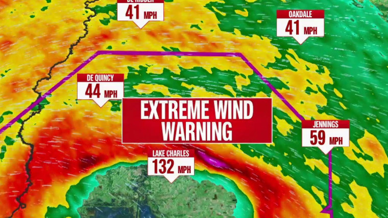
‘TAKE COVER NOW!’: Hurricane Center issues dire warning amid extremely high winds
The National Hurricane Center said the eyewall of Hurricane Laura will continue to move inland across southwestern Louisiana for the next several hours, with continuing catastrophic storm surge, extreme winds and flash flooding.
“TAKE COVER NOW!” the center warned in it latest update. “Treat these imminent extreme winds as if a tornado was approaching and move immediately to the safe room in your shelter.”
The safest place to be is in a reinforced interior room away from windows, the statement added.
Hurricane Laura already making history in Louisiana
First signs of damage in Lake Charles, Louisiana
Laura has made landfall — what’s next?
Louisiana governor closes part of Interstate 10
BATON ROUGE, La. — Louisiana Gov. John Bel Edwards said the state is closing Interstate 10 from around the Atchafalaya Bridge outside of Lafayette all the way into part of Texas, because several stretches within that area are expected to flood.
In a radio interview Wednesday night, Edwards talked of the “apocalyptic” language that meteorologists have used for the storm. “The language I’ve heard from the National Weather Service I’ve never heard before … They’re sending the strongest possible message about how serious this storm is,” he said.
He talked specifically about concerns in Cameron Parish.
“When people built back after Rita, they routinely built back to 15 feet,” Edwards said. He noted those structures would be overwhelmed.
Edwards said search and rescue efforts will begin Thursday as soon as it’s safe enough for officials to go out into floodwaters.